


Beschreibung
SparkFun RTK Facet L-Band is your one-stop shop for high precision geolocation and surveying needs. For basic users, it’s incredibly easy to get up and running; for advanced users, the RTK Facet L-Band is a flexible and powerful tool. With just the press of a button, the RTK Facet L-Band is the fastest way to take centimeter-grade measurements. With built-in corrections, 14mm Real Time Kinematic fixes are less than a minute away. By connecting your phone to the RTK Facet L-Band over Bluetooth®, your phone or tablet can receive the NMEA output and work most GIS software.
The RTK Facet L-Band utilizes corrections from u-blox's PointPerfect service broadcast from a geosynchronous Inmarsat satellite. The only setup required is a WiFi SSID and password. Once entered, the device will provision itself and periodically (once a month) update the decryption keys necessary to use the PointPerfect service. The price of the RTK Facet L-Band includes a 12-month subscription. Additional years of service can be purchased.
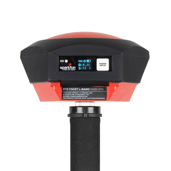
Under the hood of the SparkFun RTK Facet L-Band is an ESP32 WROOM connected to a ZED-F9P GNSS receiver, a NEO-D9S L-Band receiver (for corrections), and a variety of peripheral hardware (LiPo fuel gauge, microSD, etc). Additionally, housed under the dome of the RTK Facet L-Band is a surveyor grade L1/L2/L-Band antenna. This antenna is a unique combination of elements designed to receive the GNSS signals (L1/L2) alongside the 1.55GHz PointPerfect corrections. The built-in antenna has an ARP of 69mm from the base to the measuring point of the L1 antenna and an ARP of 68mm to the measuring point of the L2 antenna. The RTK Facet L-Band is programmed in Arduino and can be tailored by you to fit whatever your needs may be. The RTK Facet L-Band works with common GIS software including SW Maps, SurvPC, Field Genius, and any GIS software that supports NMEA over Bluetooth.
This device can be used in four modes:
Includes:
The RTK Facet L-Band utilizes corrections from u-blox's PointPerfect service broadcast from a geosynchronous Inmarsat satellite. The only setup required is a WiFi SSID and password. Once entered, the device will provision itself and periodically (once a month) update the decryption keys necessary to use the PointPerfect service. The price of the RTK Facet L-Band includes a 12-month subscription. Additional years of service can be purchased.
Under the hood of the SparkFun RTK Facet L-Band is an ESP32 WROOM connected to a ZED-F9P GNSS receiver, a NEO-D9S L-Band receiver (for corrections), and a variety of peripheral hardware (LiPo fuel gauge, microSD, etc). Additionally, housed under the dome of the RTK Facet L-Band is a surveyor grade L1/L2/L-Band antenna. This antenna is a unique combination of elements designed to receive the GNSS signals (L1/L2) alongside the 1.55GHz PointPerfect corrections. The built-in antenna has an ARP of 69mm from the base to the measuring point of the L1 antenna and an ARP of 68mm to the measuring point of the L2 antenna. The RTK Facet L-Band is programmed in Arduino and can be tailored by you to fit whatever your needs may be. The RTK Facet L-Band works with common GIS software including SW Maps, SurvPC, Field Genius, and any GIS software that supports NMEA over Bluetooth.
This device can be used in four modes:
- GNSS Positioning (~30cm accuracy) - also known as 'Rover'
- GNSS Positioning with RTK L-Band (1.4 to 6cm accuracy) - also known as 'Rover with L-Band RTK Fix'
- GNSS Positioning with RTK (1.4cm accuracy) - also known as 'Rover with RTK Fix'
- GNSS Base Station
- GNSS Base Station NTRIP Server
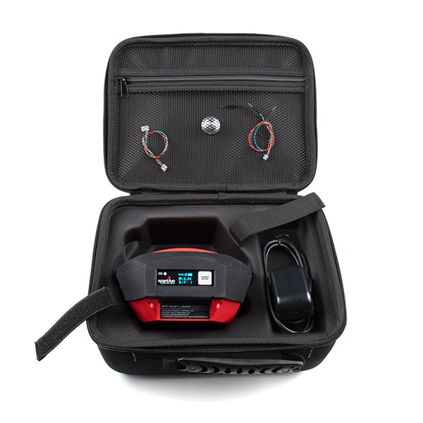
Includes:
- 1x SparkFun RTK Facet L-Band
- 1x SparkFun RTK Facet Carrying Case
- 1x Antenna Thread Adapter - 1/4in. to 5/8in.
- 1x Breadboard to GHR-04V Cable - 4-Pin x 1.25mm Pitch
- 1x GHR-04V to GHR-06V Cable - 1.25mm pitch
- 1x USB A to C Cable - 0.8m
Verschlüsselte Zahlung
Ihre Zahlungsinformationen werden sicher verarbeitet. Wir speichern keine Kreditkartendaten und haben auch keinen Zugang zu Ihren Kreditkartendaten.
Zusätzliche Informationen
Zolltarifnummer:
Herkunftsland:
Das hängt davon da, wo Sie sich befinden. Nach Übergabe der Bestellung an UPS beträgt die Lieferzeit in Deutschland ca. 2-3 Tage, innerhalb Europas ca. 1 Woche.
Wir versenden unsere Artikel mit unserem Versandpartner UPS.
Wenn wir Ihre Frage noch nicht beantwortet haben, können Sie uns kontaktieren, und wir werden uns so schnell wie möglich bei Ihnen melden.
Könnte Ihnen auch gefallen
Zuletzt angesehen
